Alley Lots. But Probably Not.
This one slipped past me when the DC Zoning Commission approved it earlier this year, but it was worth circling back to. As of July, residential use is permitted on some DC alley lots where it previously wasn’t. The change is particularly significant in R-1 and R-2 residential zones, where residential use of alley lots had been prohibited. That prohibition is now gone, but that doesn’t mean every garage, backyard or piece of land facing an alley just became a potential house.
I started looking into the change because I wanted to know how many properties were actually affected and where they were. That eventually led me to the underlying parcel data used by the DC Office of Planning. Then I started looking at the parcels themselves, and that’s when this became a somewhat different story.
First, What Is an Alley Lot?
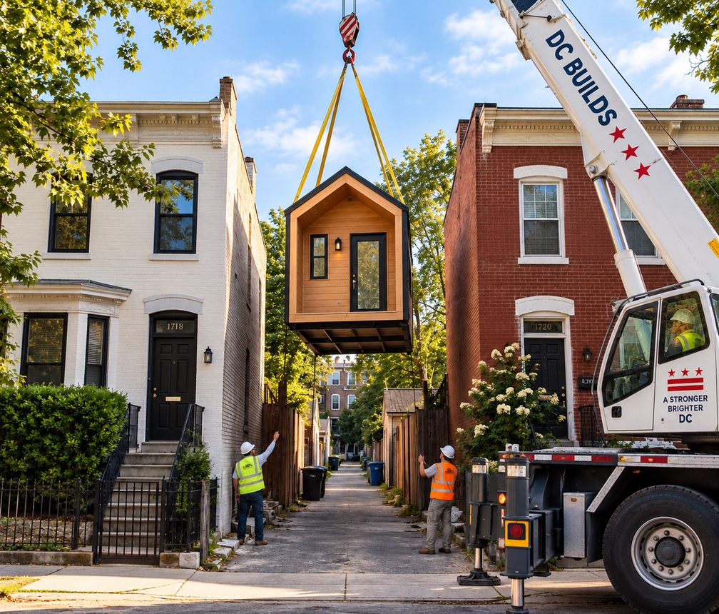
For zoning purposes, an alley lot is a legal lot without street frontage that fronts on an alley. That’s an important distinction because the word “lot” tends to conjure an image of an empty piece of land waiting for someone to build on it, and that’s not necessarily what we’re talking about here.
DC has a long history of alley housing. Some of the city’s surviving alley communities date back to a period when thousands of Washingtonians lived in alleys, often in notoriously poor conditions. The federal government eventually embarked on a decades-long effort to eliminate alley dwellings, although many survived and some were later rehabilitated.
Residential alley development didn’t disappear from the zoning code either. Under the old 1958 zoning regulations, single-family alley dwellings could be permitted under restrictive conditions, with the Board of Zoning Adjustment providing a route for some properties that couldn’t meet the matter-of-right requirements.
DC substantially rewrote its zoning regulations in 2016. That rewrite made residential development easier on qualifying alley lots in R-3, RF and RA zones, but deliberately left the city’s lower-density R-1 and R-2 zones out. The 2026 amendment essentially finishes that piece of unfinished business by removing the R-1 and R-2 prohibition.
What Changed in 2026
The new regulations allow residential use on qualifying existing alley record lots in R-1 and R-2 zones. They don’t allow a homeowner to simply carve a new building lot out of the backyard because it happens to touch an alley, and residential use still comes with conditions.
A qualifying residential alley lot must generally contain at least 450 square feet. Matter-of-right access requires either an improved public alley or alley network at least 24 feet wide at some point between the lot and a public street, or a public street within 300 linear feet of the lot through an improved alley network at least 15 feet wide. Properties that don’t meet the matter-of-right access requirement may have a special-exception route.
The amendment also increased the matter-of-right height limit from 20 to 25 feet and made other changes involving lot occupancy, yards, parking and development standards. DC removed the prohibition, but it didn’t remove the complications.
Where Are These Lots?
This was the question that sent me down the rabbit hole. The Office of Planning identified 1,897 alley lots citywide when it developed the amendment, including 172 in R-1 zones and 182 in R-2.
That’s 354 existing R-1 and R-2 alley lots affected by the change.
OP’s published material didn’t appear to identify the individual parcels, and I wanted to know where they were, so I asked. OP provided the underlying November 2025 alley-lot data used for the analysis, including the parcel identifiers, which allowed me to map all 354.
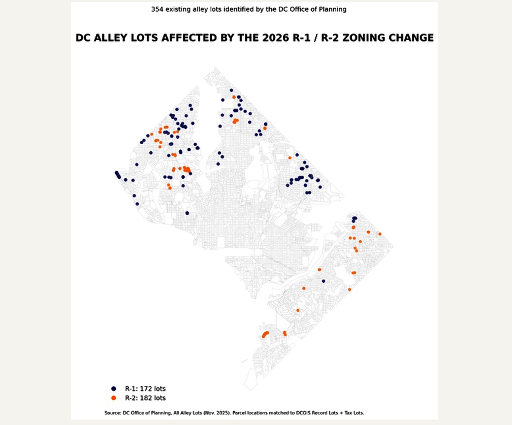
There is an important caveat to that map. Those 354 dots represent the existing R-1 and R-2 alley parcels identified by OP. They do not represent 354 buildable housing sites, and the difference became apparent once I started digging into the individual properties.
Then I Started Looking at Them
The parcel data includes information about existing use, and that alone should discourage anyone from interpreting 354 as a count of potential new homes. The inventory includes parcels classified as residential garages, parking lots and other existing uses, while some parcels are smaller than the 450-square-foot minimum required for residential development.
Others are classified as vacant, but even that doesn’t necessarily mean what someone shopping for a building lot might think it means. The map’s version of a legally vacant parcel could be landscaped, paved, used for parking or function on the ground as part of an adjoining property’s yard or access.
I spot-checked some of the parcels in Northwest DC against available imagery. I found separately recorded alley parcels occupied by garages, a tiny landscaped parcel that may or may not be legally vacant but would fit only a Barbie Dream House, and even that’s questionable once you account for right-of-way, rear-yard and side-yard requirements. Another apparently vacant alley parcel appears on the ground to function as paved access or parking associated with neighboring property.
None of that means those parcels were incorrectly included in OP’s inventory. They may be perfectly legitimate alley record lots. But a legal parcel and a practical housing site are two very different things.
Determining how many of the 354 could realistically produce housing would require something approaching a parcel-by-parcel feasibility study, including lot area, existing improvements, alley access, configuration, required yards and setbacks, usable building envelope, utility availability and last, but certainly not least, the owner’s willingness to sell to someone for a dwelling building purpose. Some properties could also present title, easement, encroachment or other questions requiring a survey or legal review.
I decided I’d learned enough. The 354 parcels tell us the universe affected by the zoning change. They don’t tell us how many houses could actually be built. My guess is relatively few.
How Did 500 Lots Become “Potential Housing”?
This is where the numbers started getting away from the underlying data.
OP’s analysis identified 1,897 alley lots citywide, of which 890 were classified as vacant. Of those vacant lots, 379 were smaller than the new 450-square-foot minimum for residential development. Subtract those and you get 511 vacant alley lots citywide at or above 450 square feet.
That appears to be the origin of the roughly 500-lot figure that subsequently showed up in coverage of the zoning proposal. But somewhere between the underlying data and the reporting, the description changed. The Ward 3 Affordable Housing News Digest reported that OP estimated “around 500 vacant alley lots around the city could permit residential development under the change.” Other coverage also characterized more than 500 parcels meeting the size threshold as potential development opportunities. That’s not what the underlying numbers establish.
The 511 figure is citywide, not the number of newly eligible R-1 and R-2 parcels. It includes alley lots in zones where residential development was already permitted before the 2026 amendment. And 450 square feet is only one threshold. It tells us nothing about whether a particular parcel satisfies access requirements, has a usable building envelope or is already occupied by a garage or another improvement. A vacant alley lot can clear the 450-square-foot threshold and still be nowhere close to a buildable residential site.
Describing roughly 500 alley lots as potential housing sites could be very deceiving. The data supports a much narrower statement: OP identified 511 parcels classified as vacant that met the minimum lot-area threshold. Whether any particular one is actually capable of residential development requires considerably more investigation.
So What Did DC Actually Do?
DC made a real zoning change. For ten years, residential use of alley lots in R-1 and R-2 zones remained prohibited while residential pathways existed in other residential zones. That prohibition is now gone.
For the owner of an R-1 or R-2 alley parcel with the size, access, configuration and physical characteristics necessary for residential development, the change could be significant. A property that previously couldn’t be used residentially may now have an option it didn’t have before.
But the practical value of that option can only be determined one property at a time. The 354 parcels identified by OP tell us the universe affected by the zoning change, while the roughly 500 figure circulating elsewhere appears to have transformed a statistical screen into something considerably more definitive than the underlying data supports.
DC made alley housing easier, but it did not make it easy.
Lot size is only the beginning of the calculation for estimation of building potential. DC zoning also regulates how much of a property can be covered by buildings, along with required yards, setbacks, pervious surface and other development standards. I wrote about some of those restrictions in my earlier guide to DC building lots.
DC Lot Building Restrictions
Sources
- DC Office of Planning. “Zoning for Alley Lots.” Project page for the alley-lot zoning amendments, including the regulatory changes affecting residential use in R-1 and R-2 zones, minimum lot area, alley-access requirements, building height, yards, lot occupancy and parking.
https://planning.dc.gov/node/1770551 - DC Office of Planning. “Alley Lots – Proposed Zoning Text Amendment,” Setdown Report, May 19, 2025. Office of Planning’s initial report and proposed amendments for Zoning Commission Case No. 25-06, including the policy background, existing alley-lot regulations and proposed changes intended to remove barriers to residential use of qualifying alley lots.
https://planning.dc.gov/sites/default/files/dc/sites/op/page_content/attachments/Alley%20Lot%20Text%20Amendment%20-%20OP%20Setdown%20Report.pdf - DC Zoning Commission, Case No. 25-06, Office of Planning – Alley Lots. Zoning Commission proceeding amending regulations governing alley lots. The revised regulations were approved by the Commission and published in the D.C. Register on July 17, 2026.
https://app.dcoz.dc.gov/CaseReport/CaseReportPage.aspx?case_id=25-06 - DC Office of Planning, supplemental alley-lot data provided to the author, November 2025. Additional parcel-level data requested from and provided by Office of Planning staff in connection with the agency’s alley-lot analysis. The data were used for the author’s independent mapping and analysis of the 354 R-1 and R-2 alley lots discussed in this article.
- Ward 3 Affordable Housing News Digest. “May 25, 2025 Ward 3 Affordable Housing News Digest.” Secondary coverage of Zoning Commission Case No. 25-06 reporting that OP estimated “around 500 vacant alley lots around the city could permit residential development under the change.” The underlying OP data were examined separately for this article.
https://scahns.substack.com/p/may-25-2025-ward-3-affordable-housing
Disclaimer
Disclaimer: The information provided on this site is for general informational and educational purposes only and does not constitute professional real estate, legal, or financial advice. While we strive to keep information accurate and up-to-date, topic details, property details, market conditions, prices, and availability are deemed reliable but not guaranteed. Readers should conduct their own independent due diligence and consult with a licensed real estate broker, attorney, CPA, financial advisor or appropriate District of Columbia government agency to verify information and policy. Content subject to change without notice. realestateinthedistrict.com and dcrealestate.channel, their owners, operators and writers disclaim any liability for any loss or damage-arising directly or indirectly from the use of or reliance on any information provided on this blog. This blog and its affiliated social media channels are the sole property and responsibility of their owner, and are not affiliated with Compass International Holdings (CIH).